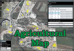
Agricultural map
Agricultural map is an application for tracing and visualizing the borders of the estates and massif with all the information about them. With Agricultural Map you can prepare contours of the massifs when applying for subsidy and participating in land agreements. 
With this application:
- No need to hand draw or check the estates of your contracts – they are visualized automatically with information
- You know which land is arable – just import the SHP file with the arable layer
- You can trace the chosen from you massifs in four different ways – by specifying the end points, combining adjacent land, import SHP file from different software product or import SHP file from navigation system
 Map, borders and information of the land are in one place
- You can outline for subsidy – Start the application, import the SHP file and trace your massif without making errors
- Automatic connection with application for contracts
- You don’t have to be overwhelmed with information – the application have convenient filters, which can filter out unnecessary information